ClimateCHIP provides several pages we call YourArea, for you to find climate and health risks globally. You can search for by geographical name, and/or click on any spot on a Google map to select the corresponding grid-cell (a square of approximately 50 x 50 km). ClimateCHIP will show you climatic data for that grid-cell, such as minimum, mean, and maximum temperatures, dew point (representative for humidity), plus heat indixes WBGT, UTCI and HI, in addition to health and productivity estimates. You can view the data for a specific month, the annual average, or annual profiles.
Your Area Today
View historic, real recorded climate data from 1980 until recently (up to the end of last year). The gridded data (0.5 x 0.5°) has been compiled by the Climatic Research Unit (CRU) at the University of East Anglia, UK by combining, validating and interpolating available weather station data into a global grid. We have calculated and included the relevant Heat Stress Indices mentoned above. This page also provides the raw data from approximately 5000 global weather stations, which have approximately 70% complete recordings since 1980.
Your Area Tomorrow
This page displays two representative future climate projections (UKesm and GFDL). These recent climate models are based on 2 of the major Shared Socioeconomic Pathways, (SSPs) 126 and 370. This webpage gives you access to 100-year calculations on a world-map-scale at one glance.
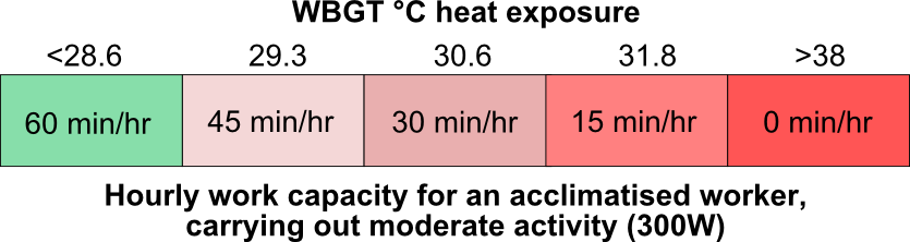
Your Area WorkHeat